BACKGROUND OF SENGEREMA DISTRIC COUNCIL
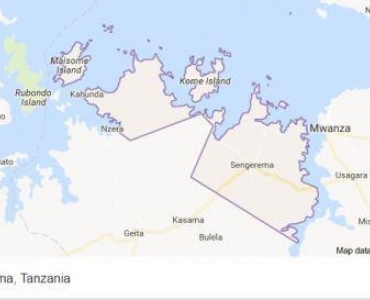
"Sengerema District Council is among the 8 district Council within Mwanza Region, Located South West of Mwanza City Council. The head quarter of Sengerema District Council is located at Sengerema town, 35 kms from Mwanza City. The district Council has an area of 8,817 square kilometers. Out of this area, 3,335 square kms are dry while 5,482 are covered by water of Lake Victoria."
LOCATION OF THE DISTRICT
"Sengerema district Council lies between altitude 20 to 30 south of equator and longitude 310 and 450 East of Greenwich. The district boarders with Ukerewe District (an Island in the Lake Victoria) to the North, Ilemela and Nyamagana Districts of Mwanza City to the East, Misungwi District to the South and Geita District to the West. "
AREA AND POPULATION OF THE DISTRICT
" The district has an area of 8817 square kilometers of which 3,335 square kilometers are covered by land, while 5,452 square kilometers are covered with water (Lake Victoria and Rivers), the area covered with forest is 677.41 square kilometers of which 638.21 square Kilometers are covered with planted forest. According to the national census of 2002 the district had a total population of 498,993 people Out of which 253, 018 were males and 254,875 were females, at a growth rate of 3.6% per year. Based on the annual growth rate, the current population (2013) stands at 686,903 of which 341,898are males and 345,005 are females.

Sengerema District Council
Anuani ya Posta: Box 175
Simu ya Mezani: 028 2590162
Simu: 0688223308
Barua pepe: ded@sengeremadc.go.tz
Copyright ©2021 SENGEREMA DISTRICT COUNCIL . All rights reserved.